Hiking in Seoul in 2026: Achasan, Inwangsan, Bugaksan, Gwanaksan and Bukhansan by subway, with official trail times, park rules, gear rental and winter tips.
PK
Peep Korea Editorial · 20 min read
Short answer
For an easy first hike in Seoul, take Line 5 to Achasan (295.7 m) or walk the city wall over Inwangsan (339 m); for a real summit, Bukhansan's Baegundae (836.5 m) is 1.9 km one way from the Baegun Visitor Center, about 1 hour 30 minutes up.2, 9, 13 Every trail here starts from the subway or a short bus ride, and none charges entry; Bukhansan National Park lets you start up its trails from 04:00 until 17:00 through November and until 16:00 from December to February.1, 4 Winter changes the rules: the national park service says crampons are a must on icy sections, and from 15 November to 15 December 2026 some national park trails close for fire season.2, 6
In Seoul you can leave a palace at 10:00 and stand on a granite peak by lunch. The mountains are not decoration on the skyline. They are where a huge share of the city spends its weekend, and you will share the trail with retirees in full gear who climb faster than you.
Below: which trail fits your legs and your day, how to reach each one by subway, what the park rules actually are, and what changes in late autumn and winter.
Updated November 2026. Trail times, rules and fares checked 3 November 2026.
Quick answer
Easiest views: Achasan, a short climb from Achasan or Gwangnaru Station with the Han River below you.13
History with your hike: the Seoul City Wall over Inwangsan and Bugaksan, open 24 hours, no booking.8, 9
A proper mountain day: Bukhansan's Baegundae, steep granite with fixed wire ropes near the top.2, 3
No boots? Foreign visitors can rent gear at three Seoul Hiking Tourism Centers.11
Short days: the sun sets at 17:34 on 1 November and around 17:13 by early December.16, 17
Which hiking trail in Seoul is right for me?
Pick by effort, not by fame. Achasan and the Seoul Trail are gentle, the city wall over Inwangsan and Bugaksan is stairs with a view, and Gwanaksan and Bukhansan are real mountains with rock underfoot. The table puts them side by side.
Trail
Start from
Summit
Official time (one way)
Effort
Last checked
Achasan
Achasan Station (Line 5) Exit 2 or Gwangnaru Station Exit 1
Times are the official walking times from the national park service, Seoul City Wall and district pages. Allow more on weekends and in the cold.
Q. Is hiking in Seoul OK for beginners? Yes. Seoul's own trail network is built so that most courses take 2 to 4 hours on mostly gentle dirt paths.14 Start with Achasan or one city wall section, and save Baegundae for a dry day when you already know how your legs feel on stone.
Q. Is there anything to reserve? No. None of these trails needs a ticket or reservation for a day hike, and the Bugaksan and Inwangsan wall sections stay open 24 hours.8, 9 Guided programs and gear rental are the only things you book.
How do I get to Bukhansan by subway?
Two sides work well. For the shortest climb, ride the Ui LRT to Bukhansan Ui Station at the end of the line and walk the road to Doseon Plaza. For the fortress route, take Line 3 to Gupabal and a bus to the Bukhansanseong trailhead.2, 4
Ui side, step by step
Ride the Ui LRT to Bukhansan Ui Station, its last stop. (Peep note)
Walk the asphalt road past Bonghwanggak to Doseon Plaza: 2.0 km, about 30 minutes. Use the toilets there.2
From the Baegun Visitor Center: 0.8 km to Haru Pass (30 min), 0.6 km to Baegun Shelter (40 min), then 0.5 km to the summit (20 min).2
Bukhansanseong side, step by step
Take Line 3 to Gupabal Station, Exit 1 or 2.
Board bus 704 or Yangju 37 to the "Bukhansanseong Entrance" stop, then walk about 10 minutes to the visitor center at 45 Daeseomun-gil.4
Walk 0.8 km of road to Daeseomun, the old main gate of the fortress, 1.1 km on to Borisa Temple, then 1.5 km of climbing to the top.3
A subway ride inside Seoul costs 1,550 won on a transit card for the first 10 km, and a single-use ticket costs 100 won more.15 Topping up a card and free bus transfers get their own page: getting around Seoul.
Q. Can I go up one side and down the other? Yes, and it is the smarter loop. Climb the longer Bukhansanseong side, then come down the shorter Ui side to finish next to the LRT station. (ref. 2, 3; Peep advice) Both routes meet at Baegunbongammun, the small gate just below the summit.3
Q. Is the Daeseomun gate open? The national park service noted in its 2026 program page that Daeseomun is under works and cannot be visited as part of that program.4 Expect signs and a detour near the gate.
How hard is Baegundae, Bukhansan's highest peak?
Hard for a short distance. The national park service describes the last stretch from Baegun Shelter as very steep, with wire ropes fixed to the rock on the hardest parts, and warns that weekend crowds can slow the summit badly.2
What that means on the ground:
Grip matters more than fitness. The rock is smooth granite. Proper hiking shoes and poles are what the park service recommends.2
The queue is real. On a sunny Saturday the narrow final section moves in single file. Go on a weekday or start early. (ref. 2; Peep observation)
The ropes are a boundary too. Areas around Baegundae marked off limits have a high fall risk. Stay on the marked trail.2
The flag at the top. A Korean flag flies on the summit all year, so you will know when you have made it.3
Q. How long does the whole Baegundae day take? Plan on 4 to 5 hours return from Bukhansan Ui Station, including the road walk and a summit stop, and 5 to 6 hours for the cross-over loop. (Peep estimate from ref. 2, 3) Start by 09:00 in November.
Q. Is there an easier part of Bukhansan? Yes. Stop at Haru Pass or Baegun Shelter on the Ui side for a big view without the steep summit block, or walk the valley from Bukhansanseong to Daeseomun and back. (ref. 2, 3; Peep advice)
Which Seoul hike is easy with a great view?
Achasan. At 295.7 m it is low and the paths are kind, yet the south-facing slope opens straight onto the Han River and the city.13 It is also the place Seoul goes to watch the first sunrise of the year.
How to do it
Take Line 5 to Achasan Station, Exit 2, and walk about 1.2 km to the trailhead; or use Gwangnaru Station, Exit 1, about 930 m away.13
Climb past the Goguryeojeong pavilion to Haemaji Plaza, the viewing deck.13
Continue along the ridge past the old Goguryeo fort sites (called bonu) to the top.13
The ridge forts date from the 5th and 6th centuries, when Goguryeo held the Han River valley, and the Seoul Trail runs along the same ridge if you want to keep walking.13
Q. Can I see the New Year sunrise on Achasan? Yes. Seoul's city news site describes Haemaji Plaza as a sunrise spot with New Year events from 06:00 every 1 January.13 Expect large crowds and very cold air; bring a headlamp for the dark climb.
Can you hike the Seoul City Wall on Inwangsan and Bugaksan?
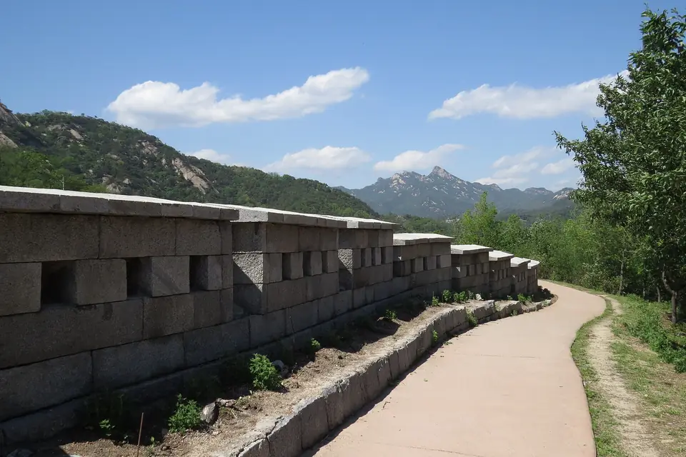
Yes, and it is the most "only in Seoul" hike on this list. The Joseon-era wall climbs straight over both mountains, with stone stairs most of the way and views across Gyeongbokgung to the towers of downtown.8, 9
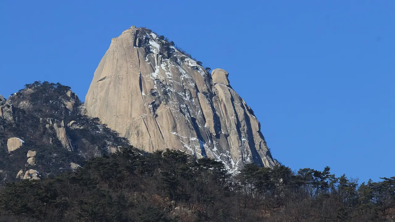
The Seoul City Wall walking path on Inwangsan, with the ridges north of the city behind. Photo: Rtflakfizer, CC BY-SA 4.0, from Wikimedia Commons; cropped to fit. Cover: Insubong Peak, Bukhansan, in winter, by Jo Hanshin, Wikimedia Commons, public domain dedication (CC0); cropped to fit.
Inwangsan section (339 m). From the site of Donuimun Gate to Changuimun: 4.0 km, about 2 hours 30 minutes. The mountain is bare rock in many places, the official page warns hikers to take care in winter, and there are no toilets once you are on the mountain, so go before you start.9
Bugaksan section (342 m). From Changuimun to Hyehwamun: 4.7 km, about 3 hours, and the stairs from Changuimun up to Baegakmaru, the high point, are relentless but short.8 Near the top stands a pine with 15 bullet marks from a 1968 armed raid on the presidential compound.8
Recommended hours on Bugaksan: 09:00 to 17:00 from November to February, 07:00 to 18:00 in spring (March and April) and autumn (September and October).8
Six Bugaksan visitor centers, including Changuimun, reopened in March 2026; they are staffed from 09:00 to 18:00 all week for information and patrols.10
The old checkpoints now only give information, so there is no ID check; the Presidential Security Service kept the mountain fully open around the clock in 2026.10
Q. Can I do Inwangsan and Bugaksan in one go? Yes. The two sections meet at Changuimun, so a strong walker can link them in 5 to 6 hours. (ref. 8, 9; Peep estimate) Have lunch in Buam-dong by the gate, then start the Bugaksan stairs. For the palace side of the day, see Gyeongbokgung and Bukchon.
Yes, if you want a craggy, rocky summit south of the river and a station right at the trailhead. It is a step harder than the city wall: Gwanak District rates its main routes three or four stars out of five.12
Three routes from the district's 2 April 2026 guide12:
Gwanaksan entrance course, 3 of 5 stars: Gwanaksan Station Exit 1, past camping grounds 1 and 4 and Kkalddak Pass to Yeonjudae, about 2 hours 30 minutes one way.
Seoul National University engineering course, 3 of 5 stars: Seoul Nat'l Univ. Station Exit 3, then bus 5511, 5513 or 5515 to the construction and environment research institute stop, about 2 hours one way.
Sadang ridge course, 4 of 5 stars: Sadang Station (Lines 2 and 4) Exit 4, via Gwaneumsa Temple and Gwanakmun, about 3 hours one way.
The district suggests the subway over driving because parking near Sadang is hard.12 The Gwanaksan hiking center sits inside Gwanaksan Station, so you can rent boots and walk straight to Exit 1.11
Q. Is Yeonjudae the real summit of Gwanaksan? Not quite. The stone at Yeonjudae reads 629 m, but the national mapping agency puts the true top on the peak just south of it, at 632.2 m, and that spot is closed to hikers.18 Yeonjudae, with its tiny hermitage on the cliff, is where everyone takes the photo. (Peep note)
Where can I rent hiking gear in Seoul?
At the Seoul Hiking Tourism Centers. Gear rental is offered to foreign tourists, and to Koreans hiking with them, at three centers next to the main trailheads.11
Seoul Hiking Tourism Center official site, checked 3 November 2026.11
The centers also have coin lockers and a lounge, which solves the "what do I do with my city clothes" problem.11 Book online before you go, check the return time on your booking, and bring your passport. (Peep advice)
Q. What should I pack for a Seoul hike? Shoes with real grip, a warm layer and windproof jacket, gloves for the rope sections, 1 litre of water, snacks and a charged phone. The national park service also lists rain gear, a first aid kit, a headlamp and a spare battery.5 An eSIM keeps your map working: see Korea SIM and eSIM.
What are the rules in Bukhansan National Park?
Short version: stay on marked trails, no smoking anywhere, no fires or cooking, no drinking at the summits and shelters, and no night hiking. The fines are set by the Natural Parks Act, and rangers patrol for them, more so in fire season.5, 6
Rule
Fine, first offence
Source
Smoking outside designated places (the whole park is non-smoking)
600,000 won
ref. 5
Drinking alcohol at listed summits, shelters and spots (Baegundae, Daedongmun, Daenammun, Samobawi and others)
100,000 won
ref. 5
Cooking outside designated places
100,000 won
ref. 5
Entering a closed or restricted area
200,000 won
ref. 5
Entering a fire-season closed trail without permission
up to 500,000 won
ref. 6
Korea National Park Service rules page and Newsis, 1 November 2026.5, 6
Other rules people miss
Night hiking is restricted in national parks from sunset until two hours before sunrise.5
Acorns and other wild produce stay on the ground; picking them is restricted because animals eat them.5
Entry cut-off: at Bukhansan control points you can start up until 17:00 from March to November and until 16:00 from December to February. That is the last start, not the time to be off the mountain.1
Q. What if I get hurt or lost? Call 119. Location boards stand every 250 to 500 m on main national park trails; read the number on the nearest one to the dispatcher and rescuers can find you.5 The Bukhansan National Park Office number is 02-909-0498.1
Can I hike in Seoul in November and winter?
Yes, and the light and empty trails reward you, but three things change: days get short, some trails close for fire season, and stone turns icy.
Fire season, 15 November to 15 December 2026. The national park service is closing 148 trail sections in 18 parks, including Bukhansan, fully or partly; the rest stay open.6 Check the live control page on the morning of your hike.7 The city wall, Achasan and Gwanaksan are not national park trails, so this list does not cover them, though local fire notices can still apply. (Peep note)
Daylight. Seoul loses daylight fast: the sun sets at 17:34 on 1 November, at 17:14 by 30 November, and earliest of all, around 17:13, on 7 December.16, 17 For Baegundae, a noon start is already late. (Peep advice)
Ice. The park service says icy sections are common on Baegundae in winter and crampons are a must.2 Light slip-on crampons are sold in the outdoor shops at both Bukhansan trailheads. (Peep observation) Inwangsan's rock steps need the same care.9
Season by season
First half of November: lower slopes hold the last of the autumn colour; Bukhansan's colour started on 14 October 2026. See Seoul in November and December for weather.
Late November to February: clear, cold, often windy summits. Pick Achasan or the city wall on icy days. (Peep advice)
Q. Do locals really eat after hiking? Yes. A plate of pajeon and a bowl of makgeolli at the bottom of the trail is a weekend ritual for many Seoul hikers. (Peep observation) Just keep the drinking for after you are off the mountain.
What is the Seoul Trail?
A 156.5 km walking loop around the edge of the city, split into 21 courses of about 2 to 4 hours each since its 2024 revamp. It links forests, streams and villages, and its access paths start from subway stations.14
It is the gentle cousin of the summit hikes: mostly dirt paths without steep grades, with rest areas and forest book cafes along the way.14 Collect all 28 stamps, in the paper booklet or the app, and the city issues a completion certificate.19
Q. Which Seoul Trail course is easy to try? The Yongma and Achasan section from Gwangnaru Station climbs onto the Achasan ridge and continues north along the forts, so you get a real view on a gentle path.13, 14
Quick FAQ
Achasan is the easiest real hike: a 295.7 m hill reached on foot from Achasan or Gwangnaru Station on Line 5.13
The paths are wide and kind, and the viewing deck at Haemaji Plaza looks over the Han River in under an hour of walking.
Yes, walking the trails costs nothing on every route in this guide, from Bukhansan National Park to the city wall and Achasan.4, 8, 13
You pay only for the subway or bus, plus gear rental or a guided program if you choose one.
Baegundae, the highest peak of Bukhansan, stands 836.5 m above sea level.3
That sounds small, but you start close to sea level and the last section is steep granite, so it climbs like a much bigger mountain than the number suggests.
About 1 hour 30 minutes up from the Baegun Visitor Center, or 2 hours 40 minutes from the Bukhansanseong side.2, 3
Add the 30 minute road walk on the Ui side, the descent and weekend queues, and most people need 4 to 6 hours.
Bukhansan Ui Station, the last stop of the Ui LRT, is the closest to the Baegundae trail on the east side. (Peep note)
For the fortress route, take Line 3 to Gupabal Station and then bus 704 or Yangju 37 to Bukhansanseong Entrance.4
You can start up Bukhansan trails from 04:00 until 17:00 from March to November, and until 16:00 from December to February.1
Those are last entry times. Plan to be back down before sunset, which falls around 17:15 in late November.16
You can, but it is a poor idea on Baegundae, where the rock is smooth granite and the park service recommends hiking shoes and poles.2
If you travelled light, rent boots at the Seoul Hiking Tourism Center near the Ui side trailhead.11
Yes on Bukhansan, according to the national park service, which says icy sections are common on the Baegundae route in winter.2
Light slip-on crampons are sold at trailhead outdoor shops. Inwangsan's rock steps also turn slippery, so carry them there too. (ref. 9; Peep observation)
Some are: from 15 November to 15 December 2026, 148 national park trail sections in 18 parks, including Bukhansan, close fully or partly for fire season.6
Check the national park trail control page on the morning you go, because closures are listed section by section.7
Not at the listed national park summits, shelters and gates, where drinking carries a 100,000 won fine. In Bukhansan that list includes Baegundae and Daenammun.5
Save the makgeolli for the small restaurants at the trailhead once you are safely back down.
No. The whole of every national park is non-smoking outside designated places, and a first offence costs 600,000 won.5
Carrying flammable items in the park is also banned, with fines of up to 2,000,000 won, and rangers patrol for smoking and cooking.6
Inwangsan is moderate: 339 m high, but most of the wall route is steep stone stairs and bare rock.9
The full wall section takes about 2 hours 30 minutes. There are no toilets on the mountain, and the rock needs care in winter.9
No. Bugaksan stays open 24 hours with no ID check, and the Presidential Security Service kept it fully open in 2026.10
Six visitor centers along the wall, including Changuimun, are staffed from 09:00 to 18:00 seven days a week for information and trail patrols.10
The wall is open 24 hours, but the recommended hours on Bugaksan are 09:00 to 17:00 from November to February.8
In spring and autumn the window widens to 07:00 to 18:00, which gives you a sunset over the palace roofs.
At the Seoul Hiking Tourism Centers near Bukhansan, Bugaksan and Gwanaksan, open 09:00 to 18:00.11
Rental is for foreign visitors and Koreans hiking with them. Each center closes one weekday: Bukhansan on Mondays, Bugaksan on Tuesdays and Gwanaksan on Wednesdays.11
Take Line 2 to Sillim, change to the Sillim Line and get off at Gwanaksan Station, then climb from Exit 1.12
That route reaches the summit in about 2 hours 30 minutes. Sadang Station, Exit 4, is the start of a harder ridge route.12
Popular Seoul trails are busy with local hikers on most days, which makes solo hiking common on the main routes. (Peep observation)
Tell someone your plan, keep your phone charged and stay on marked paths. In an emergency, call 119 and read out the nearest location board number.5
Not in national parks: night hiking is restricted from sunset until two hours before sunrise.5
The city wall over Bugaksan and Inwangsan is open 24 hours, but the official recommended hours end at 17:00 in winter, so treat a night walk with care.8, 9
It is a 156.5 km walking loop around Seoul, split into 21 courses of about 2 to 4 hours each.14
Most of it follows gentle forest, stream and village paths reached from subway stations, and walkers can collect stamps toward a completion certificate.19
Bukhansan's first autumn colour was recorded on 14 October 2026, and the lower slopes and city wall keep their colour into early November. (KMA, via our November and December guide; Peep observation)
By late November most trees are bare, which is when clear, cold winter views across the city take over from the leaves.
Showing 5 of 20
입산시간지정제 (Designated trail entry hours, Bukhansan table). Korea National Park Service (in Korean). Checked 3 November 2026. Link
북한산 백운대 코스 (Bukhansan Baegundae course, Ui side). Korea National Park Service (in Korean). Section distances and times, crampon and footwear notes. Checked 3 November 2026. Link
북한산 북한산성 코스 (Bukhansan Bukhansanseong course). Korea National Park Service (in Korean). Checked 3 November 2026. Link
[26년] 북한산성의 옛 자취를 찾아서 (2026 Bukhansanseong ranger program). Korea National Park Service reservation system (in Korean). Directions from Gupabal Station, Daeseomun works note. Checked 3 November 2026. Link
국립공원문화 (National park rules, prohibited acts and fines). Korea National Park Service (in Korean). Smoking, drinking, cooking, night hiking, drone and closed-area rules; safety advice and location boards. Checked 3 November 2026. Link
국립공원 탐방로 148곳 통제…가을 산불 예방·대응 강화 (148 national park trail sections closed for autumn fire season). Newsis, 1 November 2026 (in Korean). Link
통제정보 (Live trail control information). Korea National Park Service (in Korean). Link
백악구간 (Bugaksan section of the Seoul City Wall). Seoul Metropolitan Government, Seoul City Wall (in Korean). Distance, time, recommended hours, access. Checked 3 November 2026. Link
인왕구간 (Inwangsan section of the Seoul City Wall). Seoul Metropolitan Government, Seoul City Wall (in Korean). Checked 3 November 2026. Link
청와대 복귀에도 북악산 24시간 개방 유지 (Bugaksan stays open 24 hours; six visitor centers reopen). Seoul Economic Daily, 5 March 2026 (in Korean). Link
Seoul Hiking Tourism Center. Seoul Tourism Organization (English). Center addresses, hours, closing days, gear rental eligibility. Checked 3 November 2026. Link
관악산 가는 길 가이드 (Gwanaksan route guide). Gwanak District Office, 2 April 2026 (in Korean). Link
'확 트인 한강뷰' 아차산에서 삼국시대로 시간여행을 (Achasan: Han River views and Three Kingdoms forts). Seoul Metropolitan Government, Naeson-an Seoul, 4 May 2023 (in Korean). Link
서울둘레길 소개 (About the Seoul Trail). Seoul Metropolitan Government (in Korean). 21 courses, 156.5 km, 2024 revamp. Checked 3 November 2026. Link
운임안내 (Fare information). Seoul Metro. Checked 3 November 2026. Link
Seoul sunrise and sunset, November 2026. timeanddate.com. Checked 3 November 2026. Link
Seoul sunrise and sunset, December 2026. timeanddate.com. Checked 3 November 2026. Link
관악산공원 (Gwanaksan Park). Gwanak District Office tourism page (in Korean). Summit height. Checked 3 November 2026. Link
스탬프 안내 (Seoul Trail stamp guide). Seoul Metropolitan Government (in Korean). Stamp boxes and completion certificate. Checked 3 November 2026. Link